


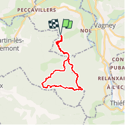
Les Étangs de Dommartin

jeanclaude12
User


3h41
Difficulty : Medium

FREE GPS app for hiking
 SityTrail
IGN / Geographical institutes
SityTrail Plus
The world is yours!
About
Trail Walking of 14.7 km to be discovered at Grand Est, Vosges, Le Syndicat. This trail is proposed by jeanclaude12.
Description
Randonnée au coeur de la hêtraie-sapinière vosgienne au départ du Col de Chenaux. La Grotte du Loup, les Roches de Mortevielle, les Etangs de la Besace et le Grand Étang, le Cendrier des Charbonniers Vosgiens sont les curiosités de ce parcours de 11 km environ.
Positioning
Comments